Como alinhar um telescópio equatorial? Como devo interpretar os discos de AR e DEC? Ao apontar para o horizonte que hora deverá marcar o disco AR?
Numa montagem equatorial os dois eixos do telescópio designam-se por eixo polar e eixo de declinação (ver
figura). Para começar o eixo polar deverá ter uma inclinação igual à Latitude do local onde se está a fazer a observação (por exemplo, no caso da Madeira, são aproximadamente 32º). Depois para tirar partido da montagem equatorial devemos apontar o eixo polar para o Polo Sul Celeste
(no caso de um observador situado no Hemisfério Sul como é o seu caso). O ponto de referência será a estrela Polaris Australis (ou sigma-octans) na constelação de Octans que embora não esteja exatamente sobre o Polo está muito próximo dele. Olhando na direcção do eixo polar devemos ver essa estrela (este alinhamento deverá continuar assim durante toda a sessão de observação).
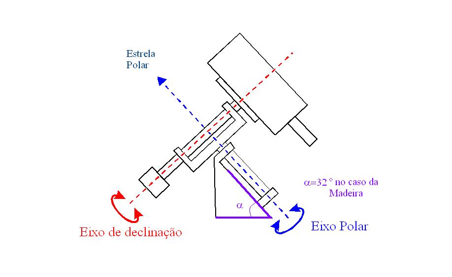
Montagem equatorial / Equatorial mount.
A montagem equatorial quando bem feita permite seguir mais facilmente um objeto no céu pois para tal bastará trabalhar apenas com um dos dois eixos do telescópio: o Eixo de Declinação. Com o telescópio bem montado deverá conseguir fazer boas observações. Deve começar com pequenas ampliações (quanto maior a distância focal da ocular menor será a ampliação obtida) por exemplo com uma ocular de 40mm. Pode centrar melhor o objeto e depois então passar para ampliações maiores.
Existem diversos sistemas de coordenadas que se utilizam em Astronomia. Dois deles são:
SISTEMA HORIZONTAL LOCAL: as coordenadas de um ponto são dadas pelo azimute (Az) e pela altura (h). O azimute será o ângulo medido sobre a linha do horizonte a partir do ponto cardeal Sul. E a altura o ângulo medido acima do horizonte (um valor negativo para para a altura
significa que o objeto está nesse momento abaixo do horizonte). Este sistema de coordenadas varia de observador para observador, ou seja, de local para local.
SISTEMA DE COORDENADAS EQUATORIAL CELESTE: neste sistema um ponto tem as coordenadas declinação (DEC) e ascenção recta (AR). Neste caso as coordenadas de um ponto não dependem de observador para observador. Existem expressões matemáticas que permitem passar de um sistema para outro.
Veja, por exemplo, a secção 1.1 da Sebenta O Universo.
No entanto pode fazer muitas e boas sessões de observação sem se preocupar, numa fase inicial, com estes assuntos das coordenadas. O mais útil se calhar será consultar
por exemplo, no Stellarium o tempo em que um dado objecto está acima do horizonte para o poder observar.
How do you align an equatorial telescope? How should I interpret the AR and DEC discs? When I point towards the horizon what value should I see n the AR disc?
In an equatorial mount of a telescope we define with
two axis, the polar and declination axis (see figure). To begin the polar axis
should have na
incklination equal to that of the latitude of the
place where you are doing the observation (for example, in the case of Madeira,
it is aproximately 32º). Next, to be able to use the
equatorial mount we should point the polar towards the southern celestial
polé (in the case of
na observer in the southern hemisphere as is
your case). The reference point should be the star Polaris
Australis (or sigma-octans) in the
constelation
of Octans that
while not exactly on the Pole is very close to it. Looking in the direction of
the polar axis we should see that star (this alignment should be maintained for
the rest of the observational session).
The equatorial mount when well done will permit you to
follow na object in the
sky because you only need to use on of the two axis of the telescope: the
declination axis. With the telescope well set up you should be able to make some
good observations. You should start with small amplifications (the greater the
focal distance of the eye piece the smaller the amplification that is obtained)
using, for example, with a 40mm eye piece. You can centre the object more before
moving on to greater amplifications.
In Astronomy we use a number of coordinate systems. Two
of them are:
LOCAL HORIZONTAL SYSTEM: the coordinates for a
certain point are given by the azimuth (Az) and by
the height (h). The azimuth will be the angle that is measured between the line
on the horizon and the southern cardinal point. The height is the angle that is
measured above the horizon (a negative value means that the object is below the
horizon at that moment). This system of coordinates changes from one observer to
the next, that is, from one location to the next.
CELESTIAL EQUATORIAL COORDINATE SYSTEM: with
this system a point hás declination (DEC) and right
acention (AR) coordinates. In this case the
coordinates of a point do not change from one observer to the next. There are
mathematical expression that permit one to change
from one system to the other. See, for example, section 1.1 of the booklet “O
Universo”.
However, you can make many good observations without
worrying, in na initial
phase, about the subject of coordinates. The best thing to do is, for
example,to consult in
stellarium when a giving object will be above the
horizon so that you will be able to observe it.